Description of Climate & Meteorology Page Content
Global Climate Models
Global Climate Models: Exploring the Reliability, Consistency, Limitations, Deficiencies, Uncertainties, and Methods of Global Climate Models in a Nonlinear and Chaotic Climate System – I discuss in general the partial differential equations involved in climate models, different types and scope of climate models, simulations, ensembles, and multi-model ensembles, the nonlinearity and chaos of the climate system, problems modeling some components of the climate system, the probability density functions (PDFs) and relative entropy that lead to climate projections, parametric and structural uncertainties, climate sensitivity and risk assessment, parameterizations, IPCC data, hindcasting, climate sensitivity, surface observations, satellite data, stratospheric cooling, possible improvements to models, and much more.
Mike’s Meteorology Page
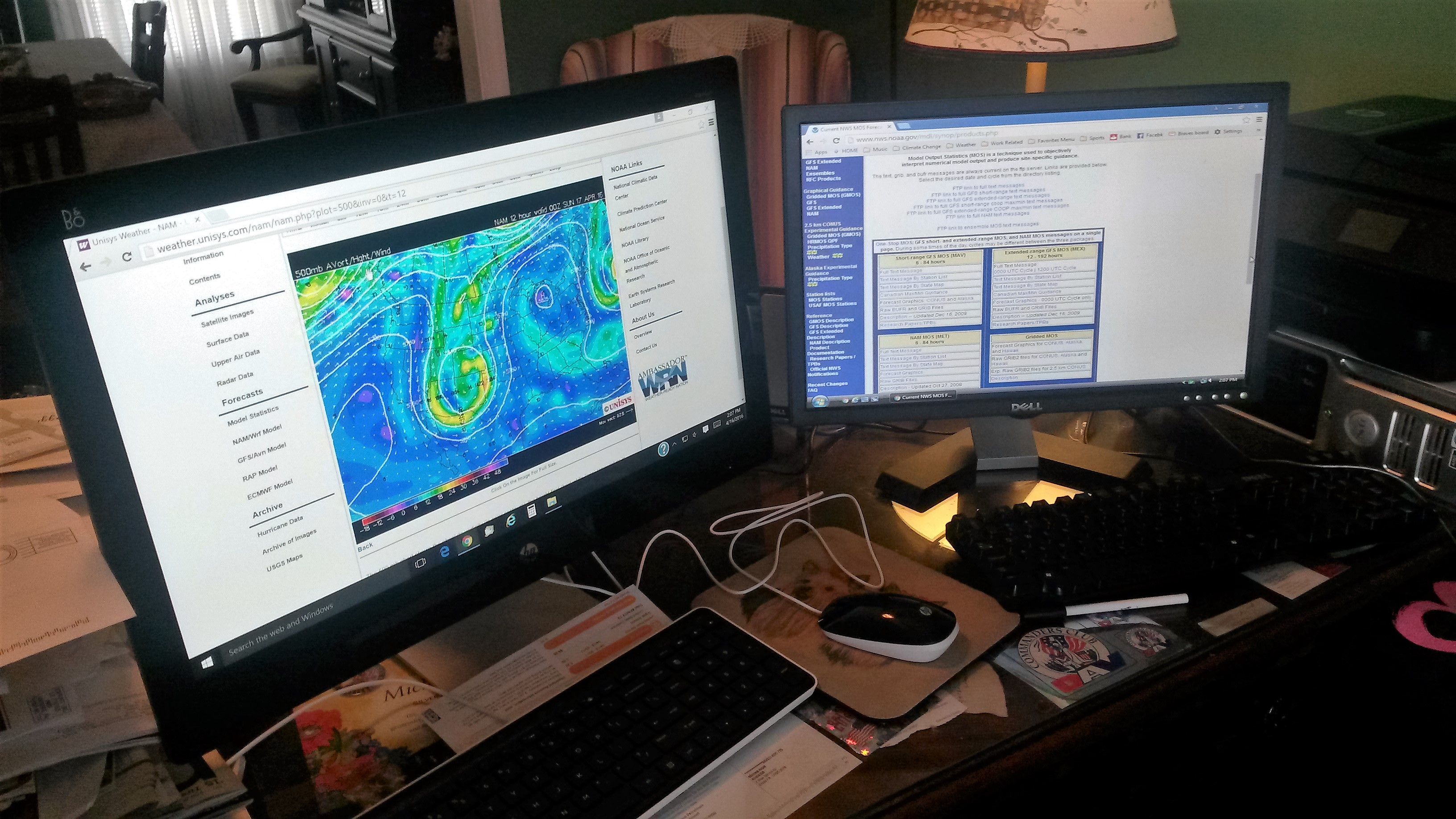
Mike’s Meteorology Page – describes Mike’s meteorological and atmospheric sciences work stations, duties, skills and accomplishments along with other information. Also provides other interesting general meteorological information, and many links to meteorological sites.
Go to… Mike’s Meteorlogical Page
Paleo Blog
Paleoclimatology Blog – While this blog touches on current anthropogenic (human-caused) warming, the primary focus is to bring to light recent climate changes and events leading up to our current warming over the last ~12,000 years, possible causes and factors, paleoclimatic findings, and to take a look at future reglaciation and a hypothetical reglaciation scenario.
Go to…Global Climate Change: A Recent Paleoclimatological Perspective
Pivotal Weather Models
Pivotal Weather – Popular models for weather forecasting.
Go to… Pivotal Weather
Weather and Climate
Provides information and opinion on weather, weather forecasting, climate, and atmospheric phenomena.
Go to… Weather and Climate Page
Weather Forecasting and Forecasts
Weather forecasting and selected weather forecasts over the last several years including some major hurricanes and snowstorms.
Go to…Weather Forecasting Page
Other Climate Change Articles
This Op_Ed was submitted to PennLive.com
 6/9/20. It was never published (or even acknowledged other than an automated reply of receipt).
Unedited version of above Op-Ed Climate Op-Ed (unedited)
Climate Change Policy Should Be About Cooperation and Communication
Climate & Meteorology News
The new laser radar, or lidar, will be the third for the UAF Geophysical Institute. It will measure temperature and neutrally charged iron in the upper atmosphere at altitudes of 75 to 125 miles, where the mesosphere and thermosphere meet. More…
Two launches to mark start of Poker Flat rocket range season
Mission: DissipationMehdi Benna, an aeronomist and planetary scientist at the University of Maryland, Baltimore County and NASA’s Goddard Space Flight Center, is leading a sounding rocket experiment to learn how solar wind charged particles dissipate their energy in the high latitude ionosphere-thermosphere, a region about 62 to 186 miles above the surface and at latitudes above 65 degrees. Mission: Beam-PIE Geoff Reeves, chief scientist for intelligence and space research at Los Alamos National Laboratory, is heading an experiment that could, in the future, lead to a way to clean up near-Earth space after a nuclear detonation at the edge of the planet’s atmosphere. The cleanup would make space safer for satellites. More… 11/2/2023

NOAA completes upgrade to weather and climate supercomputer system
Increased computing power will enable a significant upgrade to the ‘American’ forecast model
The Department of Commerce and NOAA expanded the capacity of the nation’s Weather and Climate Operational Supercomputing System (WCOSS) by 20% this week. The increased computing power and storage will help improve forecast model guidance for years to come and allow for other weather prediction advances.
More…
3/19/2023
*** WEATHER OUTLOOK*** METMAN WEATHER SERVICES℠ 19 Mar 2023 3:45 PM EDT
Winter isn’t quite over yet…A brief look at late Winter and early Spring (Final Update)
The polar vortex (PV) continues to be disrupted/weakened by a major Sudden Stratospheric Warming (SSW) event that occurred on February 16 and continues to influence weather in the Northern Hemisphere, especially in northern Europe and the UK who were notably colder and snowier and the U.S. including a major nor’easter in New England last week. It’s likely that the lingering effects of the PV disruption will continue to affect the weather across those areas for several more weeks. The North Atlantic Oscillation (NAO) and Arctic Oscillation (AO) are negative to near normal and are expected to remain that way for the next several weeks. Continued weak wave flux favors continued strengthening of a weakened PV. Currently the Madden Julian Oscillation (MJO) has now recently transitioned into Phase 1 and expected to move into Phase 2 by mid-week. While this favors intermittent cooler periods the chances now for any new significant wintry precipitation for the east coast are reduced considerably and cold air incursions in the southern U.S. are now very unlikely, especially considering the strengthening polar vortex and seasonal progression.
With the approaching Spring (vernal) equinox in the Northern Hemisphere and a strengthening PV it appears that the cold incursions and wintry pattern for most in the eastern U.S. will subside, except for higher elevations. A few warmer days in the East and South are in store this week with the central plains, the Midwest, Mid Atlantic and New England also warmer and the rest of the country remains mostly colder than average. Temperatures moderate to near normal next week in the South and near SW (i.e. Texas), and remain near to slightly above normal in the Midwest, and central plains but remain chilly in the West, far SW, northern tier and turn colder in the upper Mid Atlantic and NE. As the effects of this SSW induced PV disruption on surface weather diminishes long range outlooks for April are still trending near to slightly below average temperatures and near to slightly above average precipitation for the eastern U.S. This will be the last ‘Winter and Spring’ update concentrating on the SSW event that caused the polar vortex disruption eventually affecting the surface weather in most of the U.S.
Send me a quick note if you liked these updates.
3/11/2023
*** WEATHER OUTLOOK*** METMAN WEATHER SERVICES℠ 11 Mar 2023 1:45 PM EST
Winter isn’t quite over yet…A brief look at late Winter and early Spring (2nd Update)
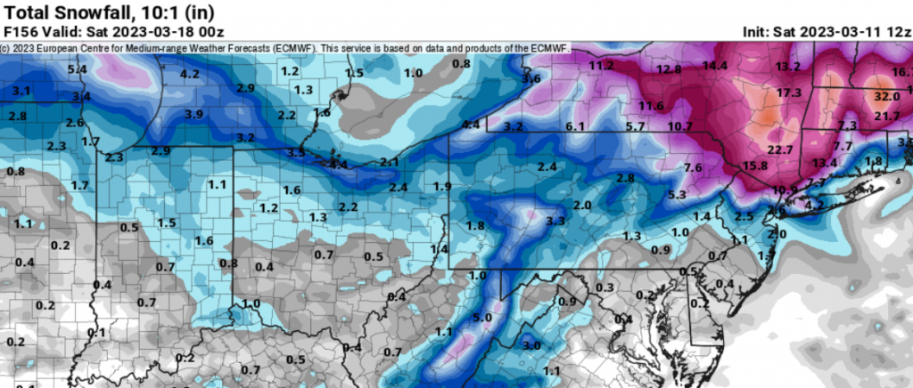
The polar vortex continues to be disrupted/weakened by a major Sudden Stratospheric Warming (SSW) event that occurred on February 16. To this point, the global tropospheric response to the SSW event has been a bit disappointing and relatively unimpressive overall notwithstanding the SSW driven heavy snows in New England recently and the cold in northern Europe including the UK, a signature SSW event response. A short term stronger response is expected in the near future in the U.S. as the AO and NAO are expected to be negative in the short term, however, the AO is trending towards neutral over the next several weeks. Model incongruities that bear watching could limit long term SSW impacts but at least for now are not affecting long range outlooks and look to be outliers. The upward planetary wave flux responsible for the SSW induced polar vortex disruption has reversed and downward wave flux is now strengthening the polar vortex. Undoubtedly, I am not highly accomplished enough for an in depth discussion of Rossby/planetary![]() waves. Historical analogs indicate that a Stratospheric Final Warming (SFW), primarily caused by solar radiative heating, will likely be delayed somewhat because of this SSW event. As discussed in my previous update the period March 10-24 appears to be the greatest chance for arctic incursions and snowfall as the effects of the polar vortex align with Madden Julian Oscillation (MJO) Phase 8. It appears the greatest chance will materialize early to mid next week (Figure 1).
waves. Historical analogs indicate that a Stratospheric Final Warming (SFW), primarily caused by solar radiative heating, will likely be delayed somewhat because of this SSW event. As discussed in my previous update the period March 10-24 appears to be the greatest chance for arctic incursions and snowfall as the effects of the polar vortex align with Madden Julian Oscillation (MJO) Phase 8. It appears the greatest chance will materialize early to mid next week (Figure 1).
As winter wanes and we approach the Spring (vernal) equinox in the Northern Hemisphere any cold outbreaks or snowfall that may result from residual effects of the weakened, although now strengthening, polar vortex will be seasonally restricted as well. Mostly colder than normal temperatures should persist for at least the next several weeks not only in central and eastern U.S. but for most of the country. For much of the east coast, a few days of above normal temperatures are also likely later next week before temperatures return to somewhat below normal again through March and into April. Precipitation is still expected to generally be above normal through March. April is still unknown as the effects of this event on surface weather begin to diminish but long range outlooks are trending slightly colder and wetter than normal.

3/3/2023
*** WEATHER OUTLOOK*** METMAN WEATHER SERVICES℠ 3 Mar 2023 9:45 AM EST
The Polar Vortex was stretched in late January and then after the Sudden Stratospheric Warming event (SSW) event on 2/16 that disrupted/weakened the Polar Vortex it became evident that a colder, wetter pattern was very possible. This was discussed previously in more detail in my “Winter isn’t over yet” updates of 2/12 and 2/26 (see below). The classic Greenland blocking setup has been in long range numerical models for a while now. Stratospheric-tropospheric coupling is now ongoing, as expected though a bit unusual, geopotential heights anomalies are favorable, and it now appears starting later next week that colder, wetter and snowier (where possible) periods are likely for at least several weeks across most of the central, eastern and even extending into the southern US. The duration of this event and its effects are yet to be determined but this pattern could linger later into March and maybe into April.
Winter isn’t over yet!
2/26/2023
*** WEATHER OUTLOOK*** METMAN WEATHER SERVICES℠ 26 Feb 2023 4:45 PM EST
Winter isn’t quite over yet…A brief look at late Winter and early Spring (Update)
The polar vortex continues to be disrupted by a relatively unconventional Sudden Stratospheric Warming (SSW) event that occurred on February 16. Numerical models are picking up on expected SSW effects and they are now evident in long term models as well. Stratospheric/tropospheric coupling is evolving but how it ultimately affects the troposphere and surface weather still has many questions in regards to when, where, and persistence. Geopotential height anomalies are currently inconclusive. Currently a strong ridge in SE US is blocking any advancement of cold air but as we go later into the 2nd week of March eventually the North Atlantic Oscillation (NAO) and Arctic Oscillation (AO), also referred to as the Northern Annular Mode (NAM), will become negative and colder air will likely penetrate deeper into the US. It remains to be seen how far south the cold air can advance as we move later into that 2nd week of March and beyond. The expected signature Greenland blocking high pressure associated with a SSW event seems inevitable based in numerous model depictions. The polar vortex disruption classification (displacement or split) is still unknown. This disruption could also evolve from a displacement to a split. If and when the polar vortex splits there is an enhanced probability that cold air could be funneled into some areas of northern, central, and the Mid Atlantic US or even farther south.
Currently the Madden Julian Oscillation (MJO) is expected to reach Phase 8 and be in place by the the 2nd week of March and in conjunction with the SSW propagation and coupling, March eventually turns notably colder, and possibly a bit snowier, by the middle to end of that 2nd week and into the foreseeable future. Prior to that temperatures in the mid Atlantic region will likely still remain average to slightly above average and atmospheric conditions a bit more unsettled, somewhat colder in northern areas into New England, and increasing chances for precipitation, including snow. IMO, the two weeks (Mar 10-24) in the middle of March will be the optimal time for a winter storm on the east coast and otherwise several other chances for snow with colder air more prevalent. Overcoming climatological barriers will diminish the chances of extreme snow events as we end March but things could be a bit cooler and wetter than normal making for a drearier start to Spring. That being said this is an extremely fluid situation with much unpredictability, especially when trying to define the changes and outcomes from this event many weeks in advance.
*** WEATHER OUTLOOK*** METMAN WEATHER SERVICES℠ 12 Feb 2023 3:45 PM EST
Winter isn’t quite over yet…A brief look at late Winter and early Spring
There is a strong possibility that the Polar Vortex will be disrupted under the influence of an imminent sudden stratospheric warming (SSW) event reducing or reversing the zonal wind flow. More will be known about future weather patterns in the U.S. once the SSW event begins. Exact location of anomalies, expansion, downward propagation, and stratospheric-tropospheric coupling will be key to the extent of the changes we experience here in the U.S. Movement of the Madden-Julian Oscillation (MJO) could also be involved. A disrupted vortex could reverse the current positive Artic Oscillation (AO) and North Atlantic Oscillation (NAO) phases to negative and increases the chances of frigid arctic air incursions into the U.S, although northern Europe tends to be more impacted, and interaction with warmer air masses approaching from the south may cause enhanced wintry precipitation. This could create alternate periods of colder and snowier weather to many places very late Feb and March. Look for some changes in weather patterns starting later in Feb. They may not be extreme (but could be in some areas) but we should generally transition away from the unseasonably warm February weather to at least slightly below average temps and slightly above average precipitation, and somewhat stormier. Long term climate analogs would limit any extreme projections at this time. It could also be a cooler and wetter Spring also depending on the extent and persistence of the disruption.
A powerful laser can redirect lightning strikes
Like a high-tech hammer of Thor, a powerful laser can grab hold of a lightning bolt and reroute its path through the sky.
In a mountaintop experiment, such a laser bent lightning toward a lightning rod, researchers report online January 16 in Nature Photonics. Scientists have used lasers to wrangle electricity in the lab before, but this is the first demonstration that the technique works in real-world storms and could someday lead to better protection against lightning.HAARP to bounce signal off asteroid in NASA experiment
An experiment to bounce a radio signal off an asteroid on Dec. 27 will serve as a test for probing a larger asteroid that in 2029 will pass closer to Earth than the many geostationary satellites that orbit our planet.
The High-frequency Active Auroral Research Program research site in Gakona will transmit radio signals to asteroid 2010 XC15, which could be about 500 feet across. The University of New Mexico Long Wavelength Array near Socorro, New Mexico, and the Owens Valley Radio Observatory Long Wavelength Array near Bishop, California, will receive the signal. More…HAARP to begin largest set of experiments at its new observatory
Bouncing a signal off the moon. Learning more about a mysterious polar light.Sending a beam to Jupiter.
Those are just some of the 13 experiments for a packed 10 days of science beginning Wednesday at the High-frequency Active Auroral Research Program. The University of Alaska Fairbanks operates the facility located near Gakona.U.S. supercomputers for weather and climate forecasts get major bump
Today, NOAA inaugurated the nation’s newest weather and climate supercomputers with an operational run of the National Blend of Models. The new supercomputers, first announced in February 2020 with a contract award to General Dynamics Information Technology (GDIT), provide a significant upgrade to computing capacity, storage space and interconnect speed of the nation’s Weather and Climate Operational Supercomputing System.NASA crews plan busy summer at Poker Flat Research Range
One crew has finished its work and departed. That crew focused on the launch facility’s lifting devices — forklifts, overhead cranes, regular cranes, slings and shackles.
The use of an FV3 core should allow for a more computationally efficient model.
The nation’s weather and climate organization, NOAA, has appointed a new director of its Environmental Modeling Center. This position essentially oversees development of the US computer models used to forecast weather around the world. The new director is Brian Gross, who fortunately has extensive experience in the field, having worked at NASA and led NOAA’s prestigious Geophysical Fluid Dynamics Laboratory. Gross becomes the full-time leader of NOAA’s modeling center at a critical time. The organization is about to substantially change the dynamic core, or engine, of its primary weather model—the Global Forecast System. This GFS model provides the foundation of many, if not most, seven- and 10-day forecasts that consumers see on their weather apps or in the nightly news. It also provides critical forecasts for hurricane tracks and other significant weather around the world. More…8/6/2018
Army Scientists create new technique for modeling turbulence in the atmosphere
Army researchers have designed a computer model that more effectively calculates the behavior of atmospheric turbulence in complex environments, including cities, forests, deserts and mountainous regions.This new technology could allow Soldiers to predict weather patterns sooner using the computers at hand and more effectively assess flight conditions for aerial vehicles on the battlefield. More…Should Cities Embrace Their Heat Islands as Shields from Extreme Cold?
The higher temperature in cities relative to their rural surroundings, known as the urban heat island (UHI), is one of the most well documented and severe anthropogenic modifications of the environment. Heat islands are hazardous to residents and the sustainability of cities during summertime and heat waves; on the other hand, they provide considerable benefits in wintertime.